Virginia State Office of Rural Health (VA-SORH).
The Virginia State Office of Rural Health (VA-SORH) was established in 1991 to create, fund, and support quality and sustainable rural healthcare infrastructure throughout the Commonwealth of Virginia. The VA-SORH is housed within the Virginia Department of Health, Office of Health Equity, and is the sole organization in Virginia that is federally designated to address and rectify health disparities affecting the state’s rural residents. The mission of the office is to partner with rural communities to identify opportunities and long-term solutions that ensure the health and prosperity of all Virginians. The VA-SORH fulfills its mission through providing technical assistance, regulatory updates, resources, and opportunities for collaboration with communities.
Priority Metrics.
The Virginia State Office of Rural Health has chosen seven priority areas and respective metrics to study and monitor longitudinally.
Click on the metric for more detailed information.
1) Education: Child readiness via Third Grade Standards of Learning Reading Assessment
2) Broadband: Percentage of households with Broadband
3) Nutrition and Food Security: Rates of Food Security and Food Insecurity among Households with Children
4) Healthy Moms and Babies: Adequacy of Prenatal Care Utilization via Kotelchuck Index
5) Access to Health Care Services: Rates of Avoidable Hospitalizations per 100,000 residents
6) Behavioral Health , Substance Use Disorder and Recovery: Rates of ER visits for Overdose (All Drugs)
7) Employment/Workforce Development: Earnings/Income per Job and Employment Rates per Census Tract
Click here to download the Virginia Rural Health Plan 2022-2026 as a PDF: VA Rural Health Plan 2022-2026

Defining Rurality in Virginia
Rurality is a multifaceted concept with a meaning that varies from persons to organizations. Rural Virginia is diverse in its geography, demographics, and cultural identity. The concept of rurality plays out differently for counties within the influence of a metropolitan area versus places that are far away from metropolitan areas. Rural cultures can exist in urban places. The proximity of rural areas to urban cores and services may range from a few miles to hundreds of miles. The most common reason for the difference includes accessibility to the amenities of a metro area, such as airports, shopping centers, and cultural opportunities. Given the rapidly changing demographic and economic landscape and link to state and federal funding, a precise definition of the world “rural” is important.
Eighty-eight Percent of Virginia is Rural
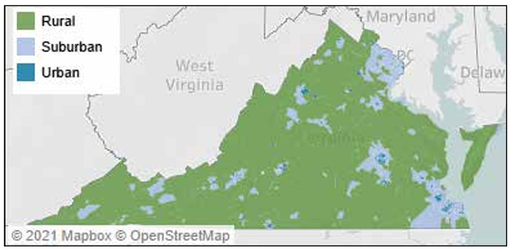
In the 2017 American Housing Survey, the US Department of Housing and Urban Development asked respondents whether they thought they lived in urban, suburban, or rural areas. When examined through this lens, it turns out that most of Virginia is rural. People living in communities covering 88% of the state consider those communities rural. Despite occupying such a large area, however, only 26% of Virginians live in these communities. By contrast, nearly three quarters of Virginians live in neighborhoods that residents believe are urban or suburban, covering just 12% of Virginia’s land. This includes the nearly 20% of Virginians who squeeze themselves into neighborhoods they consider urban.
Most Virginians associate “rural” with open spaces, a slower pace, and a small town lifestyle. Statisticians, economists, and sociologists add a different view based on economic, social, and spatial connections. Through this lens, people who live in very different settings may be connected by transportation networks, labor and service markets, and institutional relationships. People who live in similar settings may have very different economic opportunities, institutional structures, and access to services.
Urbanization Perceptions Small Area Index
Metropolitan and Micropolitan Statistical Areas
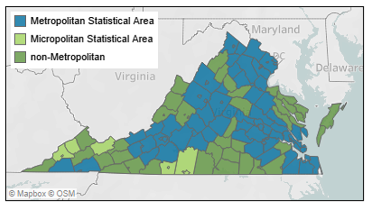
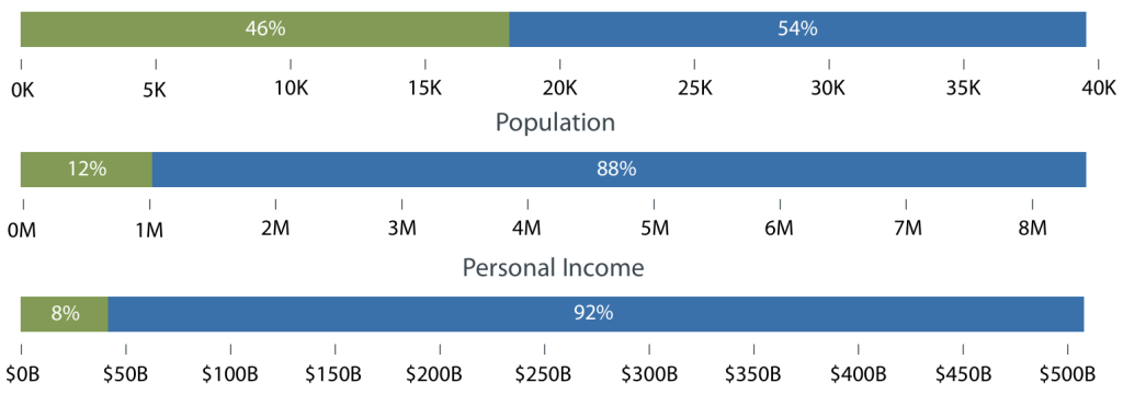
While there are various definitions of Metropolitan and Micropolitan Statistical Areas (MSAs and μSAs), the US Office of Management and Budget (OMB), provides the standard definition of urban areas nationwide. MSAs and μSAs are large areas linked by economic, transportation, and institutional networks to one or more urban cores. The principle difference between the two definitions is the size of the urban core. Under this system, rural areas are usually defined as non-metropolitan (non-metro) areas. Although there is some variation, this usually includes μSAs as well. Under this classification system, the majority of Virginia’s land mass (54%) and the greater majority of its population (88%) lies in metropolitan areas. Economically, 92% of personal income goes to metropolitan areas, while only 8% goes to non-metro areas.
Core-Based Statistical Areas in Virginia
Adding Detail
Several classification schemes add detail to OMB’s statistical areas. The simplest, from the National Center on Health Statistics (NCHS), further classifies Metropolitan counties but leaves Micropolitan and non-Metro counties unchanged. The US Department of Agriculture (USDA) gives more attention to rural counties in two classification schemes: Rural-Urban Continuum Codes (RUCCs) and Urban Influence Codes (UICs).
Rural-Urban Continuum Codes classify non-Metro counties by their adjacency to an urban area, and the size of the county population in small cities or towns, ultimately creating three Metro classifications and six non-Metro.
Rural-Urban Continuum Codes

Urban Influence Codes further distinguish non-Metro counties, including two classifications for Micropolitan areas, based on adjacency to Metro areas, and noncore counties based on adjacency to Micro and Metro areas, and the size of the population in small towns.
Urban Continuum Codes

Beyond Metropolitan Statistical Areas
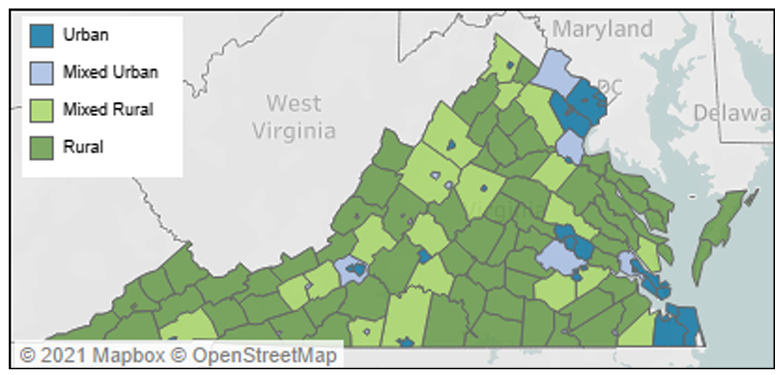
While OMB definitions set the standard for rural/urban classification it does have its limits. This system, based on connections to urban areas, often overlooks the rural character of an area, even one connected to urban systems. Metro counties with rural character, often on the fringes of MSAs, may face some of the same issues rural counties face. The Isserman Classification system uses a combination of urban area population and population density, without reference to MSAs to identify counties as urban, rural, or mixed. Using this definition a very different rural/urban landscape emerges in Virginia, one much closer to the neighborhood perceptions identified in the USPAI (US HUD’s Urbanization Perceptions Small Area Index). Under the Isserman classification used in the 2013 State Rural Health Plan, 90% of Virginia’s land area, 32% of the population, and 30% of personal income is rural.
2013 SHRP Isserman Classification
Census Tract Level Classifications
Many classification systems dive below the county-level to get to neighborhood level classifications. Most of these, like the USPAI, use census tracts, small units with populations averaging 4,000. In urban areas these can be a single building; in rural areas, an entire county. Census tracts allow a much more nuanced view of rurality.
Rural Urban Commuting Areas
Rural Urban Commuting Areas classify census tracts by a combination of population density, urbanization, and daily commuting flows. The ten primary codes, shown above, are further subdivided with secondary commuting flows, allowing a dizzying array of combinations for program classifications and policy analysis. One of the most common, also shown above, designates three primary codes as metropolitan with the rest micropolitan, small town, or rural. Even with this classification, many census tracts in MSAs are defined as rural and many without as metropolitan.
Rural Urban Commuting Areas

Federal Office of Rural Health Policy
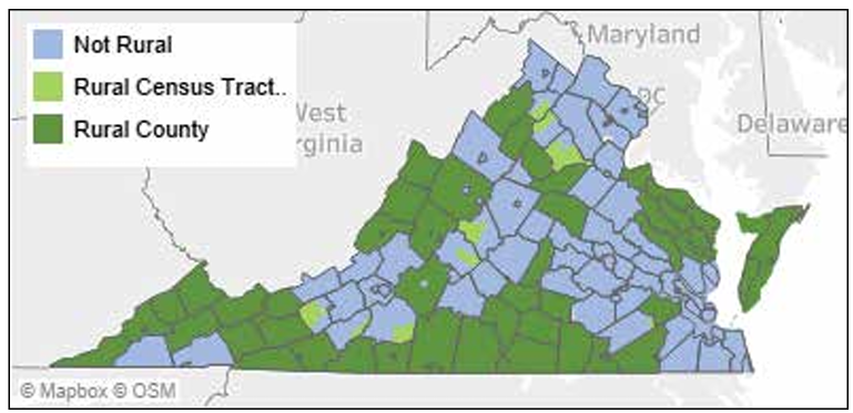
The HRSA Federal Office of Rural Health Policy uses a combination of OMB MSAs and rural urban commuting area codes (RUCA) to identify rural areas. This scheme identifies all non-MSA counties as rural, along with non-metro RUCA codes listed to the right. A wide range of federal funding designated for rural areas is directed using this system.
Federal Office of Health Policy Classification
Index of Relative Rurality
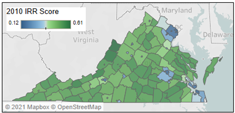
Another way to add nuance to measures of rurality is to discard threshold-based classification schemes entirely. The Index of Relative Rurality (IRR) uses a continuous measure to “score” counties based on measures of population size and density, remoteness, and urban land area. Each county is given a score from 0 (most urban) to 1 (most rural). Although the IRR does not include thresholds for rural or urban classification, the map uses the middle of the range of Virginia scores (0.365) for coloration.
Index of Relative Rurality
Changes Over Time
Most rural and urban classification schemes use a combination of urban population size and connection to an urban core to determine whether an area is rural or not rural. This means that rural areas with expanding towns often drive economic growth, and eventually become classified as metropolitan. Similarly, rural counties that increase connections to metropolitan areas, and the economic opportunities that metropolitan areas provide, become classified as part of those metropolitan areas. In parallel, metropolitan counties with shrinking urban populations, or that become isolated from metropolitan areas, are eventually classified as rural. When considered this way, rural is often defined as “what’s left” when large urban and prosperous small cities and towns are removed.
A quick visual comparison of MSA classifications based on the 1990 and 2010 US Census shows this process at work. Designated as Micropolitan* in 1990, Winchester, Harrisonburg, Staunton, and Radford cities have since been designated as metropolitan. Meanwhile, Danville has been reclassified from metropolitan to micropolitan. Existing metropolitan areas have also expanded to include a growing number of counties. Over time, a few such counties have been shed by metropolitan areas. King and Queen and Louisa counties, for instance, both connected to the Richmond MSA following the 2000 Census, are now designated as non-metro.
Comparing 1990 and 2010 Metropolitan Statistical Areas

Virginia State Rural Health Plan
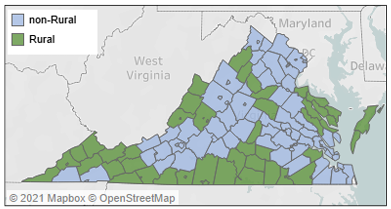
The 2022-2026 State Rural Health Plan uses the OMB classification for metropolitan, micropolitan, and non-metropolitan counties. Micropolitan and nonmetropolitan counties are classified as rural, while metropolitan counties are classified as non-rural. This system is county-based, because while some data is reported at the sub-county level, much more is available at the county level. As a commonly used system, it also allows comparisons among states and among MSAs and non-metropolitan areas.
2020 State Rural Health Plan Classification
This classification provides a convenient way to evaluate rural areas and encourages progress at addressing rural disparities. As this section shows, however, there are a number of ways to classify rural regions, many of which more closely match residents’ perceptions of their own neighborhoods. The Virginia State Office of Rural Health acknowledges the various definitions of rurality and wants to call attention to a definition of “rural” that is required for effective targeted policy and research aimed at improving the health of rural Virginia.
Land Area (Sq. Miles)
Click here to download the information on this page as a PDF: Defining Rurality in Virginia

